Oost Vlaanderen municipalities map with name.


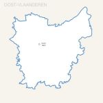
Editable map of Oost Vlaanderen municipalities with full name
Each municipality is an independant and editable vector objet (color fill and stroke, size, shape, text...)
Illustrator, Eps, Pdf and Wmf vector maps.
Supplied with the complete list of Oost Vlaanderen cities (Excel file). Updated june 2017.

Oost Vlaanderen municipalities map with name.click on the map to enlarge

Presentation

This map is also available :

  • Excel / Word map files.
  • Photoshop Psd and Jpg 150 dpi map files.


  • tags Belgium,Oost Vlaanderen,villes,Belgie,provincie,gemeente,karte,2017


    See also


    West Vlaanderen province map with capital.

    map-of-West Vlaanderen province map with capital.

    Editable free map of West Vlaanderen province
    Illustrator, Eps, Pdf and Wmf vector maps.
    Updated june 2017.
    Free vector map of Brussels region municipalities

    map-of-Free vector map of Brussels region municipalities

    Free map of Brussels region municipalities including Illustrator, Flash and svg file. Texts in Dutch
    Oost Vlaanderen province map with capital.

    map-of-Oost Vlaanderen province map with capital.

    Editable free map of Oost Vlaanderen province
    Illustrator, Eps, Pdf and Wmf vector maps.
    Updated june 2017.
    Belgium provinces free vector map

    map-of-Belgium provinces free vector map

    Free vector map of Belgium provinces Illustrator, Flash and Svg files.

    Quotation

    Use our form for your free quote requests of interactive maps or vector maps:

    Request a quote map